MAPinr offers a streamlined approach to managing KML/KMZ/GPX files, making it an essential tool for GIS professionals, outdoor enthusiasts, and anyone interested in GPS logging, measuring, and using Web Map Services (WMS). With the added benefit of offline maps, MAPinr ensures you can navigate and explore even in areas without internet connectivity.
Thank you for choosing MAPinr. We understand that the rapid evolution of Android versions poses challenges for non-profit projects like ours. However, we are committed to keeping MAPinr alive, focusing on delivering a secure, privacy-friendly, and affordable app.
We recognize that Google's requirements often necessitate a minimum Android version, which may not be supported by all devices. To address this, we provide downloads for older Android versions (prior to Android 14) on our website, ensuring that more users can benefit from MAPinr.
Are you looking to manage your points of interest or create personalized photo maps? MAPinr is your go-to solution. This ad-free Android app simplifies the management of your KML/KMZ files and allows you to display GPX files across various map types. Whether for professional GIS work or personal adventures like hiking, cycling, running, or skiing, MAPinr caters to a wide range of needs.
We value your feedback and suggestions on improving MAPinr. Please share your thoughts and ideas with us at [email protected]. We appreciate constructive feedback and understand that encountering bugs can be frustrating. We ask for your patience as our resources are limited, which may impact our ability to implement all suggestions.
MAPinr provides the following key features:
- Ad-Free Experience: Enjoy an uninterrupted, ad-free interface.
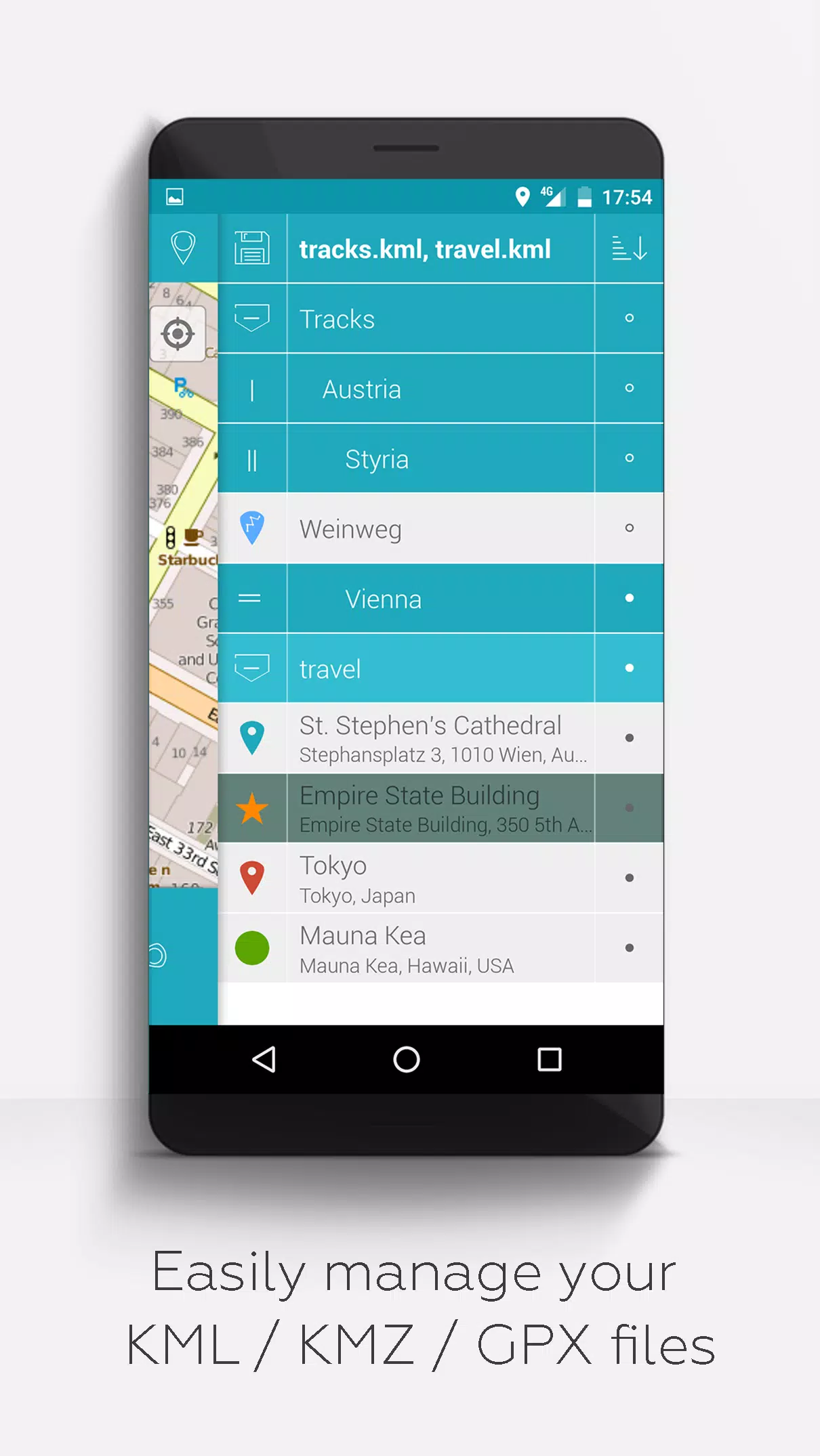
- Hierarchical Folder Structure: Easily manage multiple KML/KMZ/GPX files with an organized folder system.
- Comprehensive File Management: Create, load, edit, save, import, export, and share KML/KMZ files.
- Waypoints, Lines/Tracks, and Polygons: Create, edit, save, import, export, and share these elements.
- Photomaps: Enhance your waypoints with pictures to create engaging photomaps.
- Versatile Map Display: View waypoints, lines/tracks, and polygons on various maps, including Maps, Satellite, Hybrid, OpenStreetMap, Opentopomap, and Opencyclemap.
- Coordinate Sharing: Easily share the coordinates of your waypoints.
- Custom Colorization: Individualize your waypoints, lines/tracks, and polygons with custom colors.
- Interoperability: Open exported KML/KMZ files in other apps.
- Advanced Search: Search by name, address, and coordinates.
- Location Sharing: Share your location with friends.
- Simultaneous File Display: View multiple KML/KMZ/GPX files at once.
- KML/KMZ Merging: Combine KML/KMZ files for comprehensive data management.
- Cloud Integration: Seamlessly integrate with cloud services.
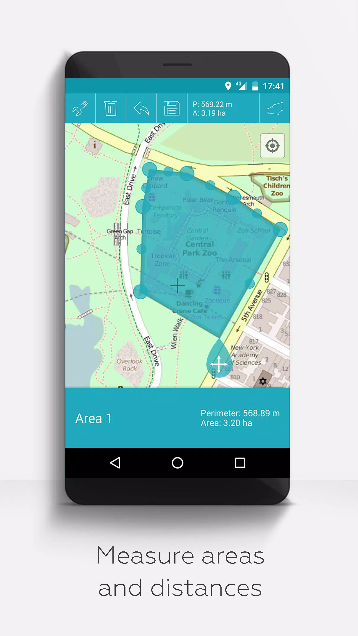
- Measurement Tools: Measure distances and areas directly on your map.
- Multilingual Support: Currently available in English, Spanish, Lithuanian, and Polish.
Extended features, available for free with donations or by liking us on LinkedIn (activate in Settings):
- Offline Maps: Download maps for free and navigate offline with OpenStreetMap.
- GPX Viewer: Display GPX files effortlessly.
- WMS Support: Access and display arbitrary map data using Web Map Services, including Opendata from www.data.gov.
- Custom Metadata: Create custom metadata for enhanced data management.
- Custom Icons: Upload and use your own icons for a personalized experience.
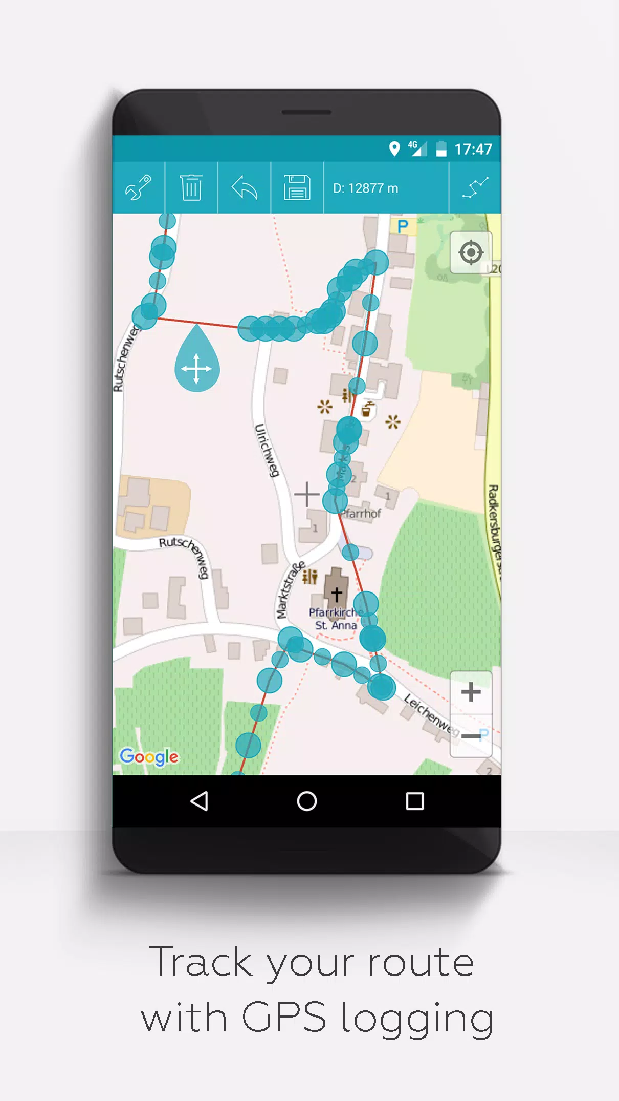
- GPS Track Recording: Record your GPS tracks to document your journeys.
Unlike other apps, MAPinr prioritizes your privacy and does not collect or sell your personal data. Donations to support our non-profit work are greatly appreciated but entirely voluntary.